MedCom 911 Emergency Service
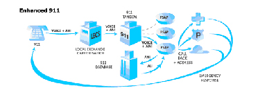
When a 911 call goes out from a telephone, voice isn’t the only thing being transmitted in the network. The telephone company switch that serves the phone is also sending out an Automatic Number Identification (ANI) signal to the telephone network. With special equipment, the 911 tandems can read the ANI information and route the callback number to a computer at the appropriate Public Safety Answering Points (PSAP).
ANI/ALI Information
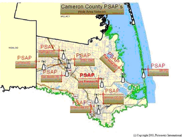
In Cameron County, a 911 call will be directed to one of nine (9) Public Safety Answering Points (PSAP’s). If a request for Emergency Medical Service is made, a 911 operator will transfer voice and data directly to MedCom.
When the 911 call is answered at MedCom, the caller’s address and telephone number are displayed on the operator’s console.
Pictometry
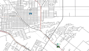
Along with voice data, ANI and ALI is presented to the call taker. ALI information displays the address and also the latitude and longitude of the caller’s address. This is displayed on a graphical map.
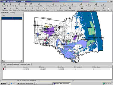
The latitude and longitude coordinates are also simultaneously presented to the Pictometry software. Cameron County PSAP’s were one of the first public safety agencies in the nation to use this technology. Pictometry is a unique patented information system that combines aerial imaging with a state-of-the-art software system that has the ability to provide Visual Intelligence™. While Pictometry libraries contain orthogonal (straight down) images like ordinary aerial imaging, over 80% of Pictometry images are oblique (taken from angles) so that features can be easily seen in their entirety. Within seconds, using Pictometry Electronic Field Study (EFS) software, an operator can literally see everywhere, measure anything and plan everything. This means that operators can literally view and analyze any house, building, intersection, fire hydrant, tree or any feature in Cameron County. Features can be viewed from at least three and up to twelve different directions. The images are all in a full color, high resolution, and in digital format.


Computer Aided Dispatch
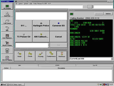
While the 911 dispatcher confirms the caller’s location, the ANI/ALI information is automatically downloaded into the Computer Aided Dispatch system (CAD) system. The entire process of call receiving, dispatching and fleet monitoring is accomplished through the CAD. Each call received by MedCom is assigned a unique call identification number. Every stage of the ambulance call is monitored and recorded (including voice and data) in an SQL computer database. This information is electronically archived.
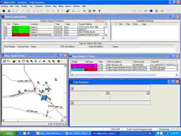
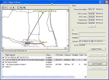
CAD Flight Tracking
Along with the CAD’s dispatching and fleet monitoring capability, there is an integrated set of features specifically for the Valley AirCare airplanes.
Upon lift-off, information is entered such as the number of souls on board, fuel and estimated time of arrival for the aircraft. Flight heading and distance information is calculated for each leg of the flight, and is recalculated throughout the flight. Timers provide real-time information about the next required position update, the estimated time of arrival to the next landing zone, and the time spent at the scene or destination. Fully integrated maps show the flight plan and current aircraft location.
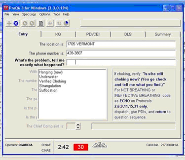
PRO QA Software
As the location is being identified and processed, the caller’s nature of the problem is determined. ProQA software is activated and used to identify the nature and seriousness of the call and to give pre-arrival instructions. Pre-arrival instructions are based on the concept that dispatchers are the patient’s first medical contact and can provide basic first aid via telephone by asking specific questions and giving the 911 caller instructions before the first responders and ambulance arrives. The questions and instructions are based upon a national protocol. Poison Control and hazardous materials (Hazmat) services are also available if their need is identified.
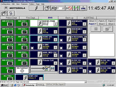
Radio Communications
Voice communications is established with the aid of mobile data terminals in the ambulances and the 800 MHz radio trunking system.
AVL/GIS
The CAD system databases contain all operational information related to vehicle status and emergency and routine incidents, which are pending, or in progress. Each update to vehicles and incident information is recorded by the CAD system and forwarded to the mobile data terminals in the ambulances.

In the field, the GPS receivers installed in the ambulances send a steady stream of location updates to the CAD. The CAD mapping display presents the dispatcher with an accurate picture of location and status of the entire ambulance fleet on a geographical map.